The Voyage of Irish Ayes

Mike and Pat began their "Great Loop" trip aboard their boat, Irish Ayes, on 6 October 2006. Irish Ayes is a 1986 Gulfstar, Wide Body Motor Yacht. Our voyage will take us from Knoxville, Tennessee, to Florida and the Bahamas in November, returning to Florida in December. In April 2007, we will aim the pointy end of the boat north up the east coast of the USA, stopping wherever looks interesting. We hope you enjoy our trip with us by way of this link. Mike and Pat

Saturday, June 30, 2007

Lake Ontario to Trenton, Ontario, Canada

We departed Oswego, NY, at 6am on 25 June 07, passing the picturesque lighthouse at the entrance to Lake Ontario. The winds and seas were expected to be calm, and they were, for the most part. The Great Lakes have a reputation for being wild and dangerous in strong winds, and the crew of IRISH AYES decided that we don’t like strong winds on open water after our experience in Marathon, FL, back in December 06. Seas on Lake Ontario have been recorded at over 40 feet in a bad storm, and that is at least twenty times higher than we like. So, when the weather reports all agreed that today is the day to cross, we did. And it was a beautiful, smooth crossing. The wind picked up a little by late morning, but by then we were across the lake and into protected water.

We crossed the lake with two other boats, STARGAZER, with Ginger and Laura as crew, and SEAQUEL, with Barry and Sheryl. We have been with all of these wonderful people before, and it has been fun spending time with them again, both in Oswego for the few days we were there, and then in Trenton, Ontario, Canada, where we are now.

It was a long day, in which we covered over 100 miles. The water and countryside was beautiful, and it was a good day to make a long voyage. We noticed a few differences in the way things are done in Canada. Channel Markers, for example, are a lot smaller and shaped a bit different than we are accustomed to in US waters.

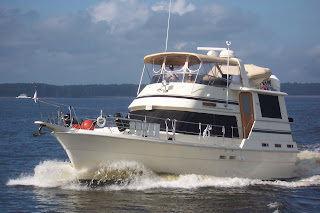
We arrived at Fraser Park Marina, in Trenton, Ontario, at about 4pm, and we were tired. Then, the adventure began. The dock where the dock master wanted IRISH AYES to land was between two other boats, a new Cruisers 52 on one side, and a sailboat of about the same size on the other side. Mike had to bring the boat between these two other boats. The adventure was that he had to try to bring her in sideways. IRISH AYES doesn’t go sideways very well. Factor in the ubiquitous afternoon winds, and Mike had his work cut out for him. With Pat’s help (thank goodness for headsets), a little luck and some skill, he was able to squeeze our boat in between the other boats and land her with no damage to anyone’s boat, or his ego. As always at a time like this, there is a crowd watching and betting whether or not the Captain is going to get in without any damage. The Dock master was impressed, as was everyone who was watching. We spent two days in Trenton, walking around town and seeing the sights. So far, Canadians have been very friendly, as expected, and their country is beautiful. Soon we begin one of the highlights of this trip, the Trent-Severn Waterway. Stay tuned...

Sunday, June 24, 2007

The Erie and Oswego Canals


We arrived at the junction of the Hudson River and the Erie Canal on 17 June 07. The only directional sign on the entire trip so far was this sign telling us which way to the Erie Canal.

Our first stop in the Erie Canal was in Waterford, NY, at the Visitor’s Center at Mile 0. They have a free dock with water and 50/250 electric available, and so far, this has been the only freebee we have encountered since we departed Knoxville. There are free docks along the way here and there, but not free water and electric. The staff at the Visitor’s Center could not have been more friendly and welcoming. They were very nice people who will do nearly anything to make your stay a pleasant one. For example, we needed to go to the NAPA Store for fuel filters, and when Mike asked one of the volunteers, Frankie, for directions, he put us in his car and took us there. Frankie is a delightful older gentleman who served in the US Navy on warships in both the Atlantic and Pacific during World War II. It was a pleasure to meet him.

Wandering around Waterford was fun and interesting. We saw the remnants of the original canal. The original canal was only four feet deep and forty feet wide. Back then, canal boats were pulled on towlines by mules and horses, working shifts of six hours on and six hours off. Waterford is a pretty little town, a bit old and decaying, but making a comeback.

After walking around Waterford for a couple of hours, we stopped at Kielty’s, an Irish Pub, for a cold beer. The owner is from Ireland and spoke with the Irish brogue. His brother, Liam, was visiting from Ireland, and helping out at the Pub. Liam’s Irish brogue was more difficult to understand. We enjoyed their tales of Ireland. Ireland is on our list of countries to visit and talking to them only wetted our appetite to visit there soon (when we finishing this boating adventure). After this stop, the Captain was well rested.

While at the dock in Waterford we met Don and Teresa, who own GREAT ESCAPE, a Gulfstar 44 that is similar to ours, and of course we had to see each other’s boats. They are a very nice couple, both retired Naval officers, who are “doing” the loop as well. It was great to meet and hang out with them for a while. I’m sure we’ll see them again.

We began our trip west on the Eric Canal on Tuesday, 19 June. The first thing we encountered was the first “flight of five” locks we had to traverse. The locks on the Erie and Oswego Canals are much different than other locks we have encountered. Once in the lock, you either tie a line around a vertical three inch pipe, a vertical half inch, rubber coated cable, or worst of all, grab and hold on to ropes that are hanging down the sides of the lock. Imagine Pat and Mike holding 40 thousand pounds of boat with just two ropes hanging down, with the wind blowing like crazy. It was not pretty, to say the least. Going through these locks with other boats only increased the stress level. Keeping your boat off other boats and other boats keeping their boat off ours was definitely challenging. After a day of these locks, everyone was exhausted!

We didn’t have it as bad as some others though. One boat behind us in these first series of locks was a catamaran, a very wide boat, and as is characteristic of catamarans, there is not much boat in the water, since their draft is very shallow. This makes for a boat that can be captured by the wind and moved all over the place. This particular boat had a bad time, since the wind was blowing pretty hard. The captain could barely control his boat. He got sideways in each lock, as you can see in this picture.

Another great aspect of the NY State Canal System is their free docks at each lock, and also in some of the small towns along the canal. While there are no amenities such as water or electric for boaters at the locks, they do have long walls on the east and west sides of each lock that boaters can tie up to for the night, which saves you from getting your anchor dirty, or going to a marina and paying to rent a piece of water for the night. We stayed on the free lock walls on both the Erie and Oswego Canals every night, with one exception.

In Little Falls, NY, we stayed at a small marina, so we could pump out our holding tank and fill our water tank with fresh water. BUBBLES and GREAT ESCAPE also stayed at this marina for the night. Since we had been traveling with Roger and Dixie, the crew of BUBBLES, and since it was Dixie’s birthday, we all went to a restaurant for dinner to celebrate. In many places, Little Falls included, restaurants and other commercial establishments will come to the marina and pick you up, and then bring you back to the boat later. It is a very convenient arrangement. We also replenished our supply of Captain Morgan’s Rum while in Little Falls.

The Erie Canal and the Oswego Canal are beautiful bodies of water. With the exception of the locks, a total of 29 to get through both canals, we had a very pleasant voyage on these historic waterways. We saw very few boats, maybe one or two a day, going east, and only a couple of working boats that were dredging along the way. All in all this was a very nice trip.

We arrived in Brewerton, NY, on Thursday, 21 June, and spent the night on the free dock which they provide. On Friday we made our way a few miles to Winter Harbor Marina where we fueled the boat and pumped out the holding tank, and then made our way to the intersection of the Erie and Oswego Canals. From there, we headed north through seven locks to the south shore of Lake Ontario. We tied up to the free lock wall and spent the next three days exploring Oswego New York, and waiting for a good weather window to cross Lake Ontario. Next stop is Canada.

Since phone service and internet service is very expensive in Canada, we will be adding more to our blog as we have the opportunity to plug into a Wifi net. Stay tuned.

The Hudson River

We departed Liberty Island anchorage on 14 June and, from New York City, we began the 150 mile trip up the Hudson River to Waterford New York, which is the beginning of the Erie Canal. As we passed through the New York City waterfront, we saw all of the landmark buildings, to include the Empire State Building.

The city is beautiful from the water, unless you get too close to shore and you can see the rundown industrial docks, and a lot of dirt and other unpleasant stuff.

As we passed under the George Washington Bridge at the north entrance of the City, we almost immediately left the big city for rural country side. The contrast is striking to go from one of the world’s largest cities, to farmland and country, in less than a few miles.

Our first stop up the Hudson was at Haverstraw Marina, about 40 miles north of NYC, in Haverstraw, NY. This was a nice marina, but not nice enough for the $2.00 a foot they charged to dock IRISH AYES. But, we needed to stop for fuel, food, pump out, and to step ashore, so we paid it.

Now, let me tell you about the fuel dock. I know sometimes you complain about slow gas pumps when we fill up the car, but this diesel fuel pump was the slowest pump either of us has ever experienced in our lives. You may not believe this, but to fill our tank with 238 gallons of diesl took OVER AN HOUR AND A HALF !! Yes, I can pee faster than that (Mike says). And at $2.99 a gallon, you’d think they could afford a faster pump. Sure glad we don’t have to fill up very often.

While at the Marina we decided to take the bikes and go find a grocery store. After pumping our bikes up several hills we finally found a pretty good grocery store about four miles from the marina, and bought about 10 bags of groceries. With our bike baskets full, and Mike’s rucksack filled as well, we rode downhill back to the marina. All in all a successful trip.

We departed Haverstraw on 16 June, and headed up the Hudson, next stop, Kingston, NY, where we would see our friends Lee and Brenda Jetton, who have a Gulfstar 44 just like ours. They just had their boat, MOONLIGHTER, painted, and it is beautiful. After we anchored IRISH AYES in Rondout Creek, we took our dinghy off the boat and motored to their marina. Brenda fixed dinner for us, and it was delicious, and visiting with them again was great. We last saw them in Charleston, SC, back in April. We greatly enjoyed our visit with Brenda and Lee. The next morning we departed Kingston, and headed north to Waterford, NY.

We have been amazed at the beauty of the Hudson River. It is one of the prettiest bodies of water we have been on, and looks a whole lot like the Tennessee River. Interestingly, the Hudson is tidal, and can have as much as a 3-4 know tidal current, so it pays to play the tides. Our boat travels at 8 knots, and with a 3-4 knot tidal current, we can increase or decrease our speed, and fuel consumption, depending on which way the tide is running. Needless to say, we departed on a rising tide each day to get the benefits of the tidal push.

We passed many beautiful buildings, not the least of which was the US Military Academy at West Point. It is a stately, rock solid facility that makes this Army family very proud. We also passed the New York State Mental Hospital, and Pat threatened to take Mike ashore and leave him there. But, since she still needed him to drive the boat and fix things when they break, she passed on that opportunity.

The water on the Hudson is deep, thankfully. We have had enough shallow water for a while. At one point our depth sounder registered 155 feet. There are lighthouses all along the Hudson, and Pat took at least two pictures of each one of them.

After passing through Albany, New York, we arrived in Troy, where the Troy Lock and Dam designates the end of salt water, the end of tidal water, and back into the inland rivers and lakes of the USA and Canada. Since salt water is hard on the boat, and tidal water is a pain, we were happy to pass through Troy Lock. Next stop about two miles away is Waterford, New York, and the beginning of the Erie Canal. Stay tuned.


Thursday, June 21, 2007

New York City

The trip from Manasquan to NYC was great. We ran outside in the Atlantic Ocean, and she was calm enough to skip rocks on, if we had any. As we made the turn to northwest around Sandy Hook, NJ, there was the skyline of the Big Apple.

There are several ship channels leading into NYC, and there were numerous ships making their way. Our job was to stay out of their way, as they travel fast you know. It’s amazing to think that a ship that is two city blocks long can travel about twice as fast we can in our small 44 footer, but they do. It’s sort of like watching a huge airplane in the sky. They look as if they are going so slow they will fall out of the sky, when actually they are going a couple of hundred miles an hour. In any event, they go faster than we do so we have to stay out of their way.

As with any major metropolitan area, there are many interesting sights to see. On our left was Staten Island, and on our right was Long Island, and then Brooklyn. A little further north of Brooklyn is Manhattan.

We passed under the Verazzano Narrows Bridge, and there we were in New York Harbor!!

One of the highlights for us was seeing the Statue of Liberty. We could see her for miles before we reached her, and she is beautiful. One of our goals on this trip was to anchor behind Lady Liberty, and we accomplished that, at least for a while.

Why just for a while you ask? Well, let me tell you about the ferry boats, tour boats, ships, tugs, barges, and other assorted water craft that ply the waters of New York Harbor near the Statue. The ferry and tour boats are the worst, in that they go from point A to point B as fast as they can, creating a wake that will rock your socks off. Now, with us anchored by the statue of Liberty, we were a direct target for the huge wakes launched by these boats, which rocked us like crazy. So, we decided to take up the anchor and move around the corner and anchor just off Liberty State Park. We could still see Lady Liberty from our new anchorage, we just were no longer right next to her. Oh well…

We stayed in New York for two nights, anchored next to Liberty State park. Several other boats were there with us, to include BUBBLES, new friends we met in Cape May. BUBBLES is a Nordic Tug 37, and is a very nice boat. Her crew consists of Roger, Dixie, and Skipper, a Portuguese Water dog.
We did not get off the boat and go into the City, much to the disappointment of Miss Patricia, who fell in love with NYC back in 1992 when we visited Manhattan for a week. Mike, on the other hand, had no desire to go into the city, where he would be on the alert for muggers, and other assorted thugs, not to mention figuring how to get around the city to see the sights without breaking the bank. We departed The Big Apple on 14 June, heading north up the Hudson River. Stay tuned

Sunday, June 17, 2007

On The Way to NYC

We left Utsch's Marina in Cape May on 10 June about 10:00 a.m. The inside route to Atlantic City, NJ, was terrible. It is a very shallow, and narrow, channel that runs from Cape May, through Atlantic City, to Manasquan, NJ. Most of the written reports on this route advise to leave on a rising tide, and watch your position very carefully, which we did. About half of the written reports say “Don’t do it.” Just as many reports say that the inside route is just fine, if you are careful.

Our experience can be summed up by saying, NEVER AGAIN!! We began the trip about a half hour after low tide, which was probably two hours too early. We hadn’t gone 10 miles before we ran aground twice. Mike was able to get us off the soft grounding, but with 40 more miles of this to go, we knew we were not going to like this route. There were numerous tight, and not well marked, turns; miles of very shallow water, and very slow going the entire way.

To make matters worse, just as we were getting tired and ready to stop somewhere for the night, we encountered six bridges that needed to be opened for us, two of which are closed from 4-6pm. We arrived at the first of these at 4:50pm, which meant that we cut circles in the water for over an hour. Once we made it through the last bridge though, we were headed for our anchorage at Rum Point Island, which turned out to be one of the best we have dropped our anchor in. Looper boats BUBBLES and LE REVE were there when we arrived.

The weather the next day was predicted to be good out in the Atlantic, so out the Atlantic City Inlet we went, and turned north toward Manasquan, New Jersey, an open water trip of about six hours. Thankfully, the weather reports were correct, and we had a beautiful, and calm day out in the ocean.

When we arrived at the Manasquan Inlet, we made our way through the narrow entrance, and then found ourselves in shallow water again as we made our way to our anchorage. We had to pass through Glimmerglass Creek railroad bridge, which is very narrow. This anchorage was not nearly as nice as Atlantic City. There was room for only about four boats, and the water in the anchorage was only 5-8 feet deep. With a five foot tide, we had to pick our spot to drop the anchor very carefully. Otherwise we would find ourselves sitting on the bottom in mud at low tide. After a couple of tries, we finally found a pretty good spot and dropped the anchor. Mike still wasn’t very comfortable with this location, and probably didn’t sleep all that well, but it turned out to be ok.

At daybreak, we made our way back out the Manasquan Inlet, out into the Atlantic Ocean again, headed for New York City. Pat loves lighthouses, and there are numerous different lighthouses in the north eastern USA, and she is trying to get a picture of every single one of them as we make our way north. Next Stop, NEW YORK CITY !! Stay tuned.

Cape May, New Jersey

We arrived at Cape May, New Jersey, on 7 June, after a great and uneventful cruise down Delaware Bay, a body of water with a less than peaceful reputation. We turned north into the Cape May Canal, headed for Utsch’s Marina. Once again it was high adventure keeping IRISH AYES off the sand bars and other shallow water in the canal. Cape May Harbor wasn’t much better. In fact, the water in the Harbor is at best three feet deep under our keel, with two feet or less quite common. Once again though, the Captain steered a safe course right into our slip at the marina.

On the way in on the Canal, we took a picture of a boat full of crab traps. If you haven’t seen one, here’s a boatload of them. These are the traps that have made us crazy for about 2,000 miles. Each of these little traps are connected to a float on top of the water by a long length of very tough ¼ inch line that can become wrapped around your prop or prop shaft, as happened to us in Florida back in early February.

Two Looper boats—FOXY and SANDPIPER—were at Utsch’s Marina at Cape May when we arrived on Thursday, 7 June, 1:30 p.m . SONATA and BUBBLES, also Loopers, arrived sometime later.

SANDPIPER is owned by a delightful couple, Bob and Ann, from Nashville. Bob, sadly, is a rabid Vandy Commodore fan, and delights in giving Mike grief about the relative lack of academic excellence, and the police record, of some Tennessee Volunteer football and basketball players. Mike thoroughly enjoys giving it right back to Bob regarding the abysmal athletic achievements of the Commodores. They have fun with it, and their wives just shake their heads.

Shortly after we arrived in the slip, we welcomed the crew of SONATA, and later that evening we enjoyed cocktails on SONATA with Charlie and Bonnie, as well as Roger and Dixie from BUBBLES. This boating community is very open, welcoming and friendly, but plays havoc with one’s BA level.

On Friday, we decided to walk from the marina to downtown Cape May and the beach. It was a very warm day, but the much needed walk/exercise was welcomed, if not desperately needed. We walked on the beach for a couple of hours, and then stopped at a corner bar for refreshments.

Cape May is known as “the nation’s oldest seashore resort,” and the entire town has been proclaimed a national historic landmark. The streets are lined with Victorian homes and small gingerbread cottages, many of which are now commercially owned.


On Saturday, we got out our bicycles and rode around town. There was an arts and crafts show at one of the big historic homes, so we stopped and walked around for a while. The tallest man of Cape May was strolling through the crowd and was the highlight of the show for the young ones.

From there, we took off for the Cape May Lighthouse. The surrounding grounds of the Lighthouse are a work in progress with walking trails, nature trails, bird sanctuaries, etc., being developed. The Cape May Lighthouse is located at Cape May Point State Park. The lighthouse was built in 1859, and is the third known lighthouse to be built at Cape May Point. The exact locations of the first two lighthouses built there are now under water due to erosion. The Cape May Lighthouse is an active lighthouse operated by the U. S. Coast Guard, and provides aid to navigation for mariners.

On Saturday evening we had dinner with Charlie and Bonnie, the crew of SONATA, at The Lighthouse Restaurant. Once again, the crab cakes were delicious.

We departed Utsch’s Marina on Sunday morning at 10:00 a.m., our destination an anchorage near Atlantic City. We decided to take the inside route, New Jersey’s ill-reputed Intacoastal route, because the alternative was to go out into the Atlantic Ocean, and the weather and seas were too rough for that on this day. We would live to regret that decision, but that’s another story. Stay tuned.

Wednesday, June 13, 2007

Chesapeake & Delaware (C & D) Canal to Delaware Bay

Once we stuck our nose out into the Chesapeake Bay from the Patapsco River early on the morning of 6 June, the seas were 2 to 3 feet, mostly three feet, for the first two hours of the trip. It was a little uncomfortable, but it could have been a lot worse. If we haven’t said so already, the Chesapeake can be downright dangerous if one goes out in the wrong weather. After our experience in Marathon, FL, we have learned to watch the weather very closely. Once we got to the point in the northern Chesapeake where the Bay narrows, the seas flattened out and the ride was smooth for the rest of the trip.

We heard a “May Day” on the marine radio while traveling today, and a May Day is never a good thing. It means that there is an immediate danger of loss of life, the vessel sinking, or both. In this case, a Sports Fisher-type boat radioed the Coast Guard that smoke was coming from his engine compartment. The USCG responded immediately, on the radio, asking all the right questions (location of the boat, number of people aboard, injuries, safety equipment aboard, and so on). The last contact that we heard was that that the smoke had gone from grey to black and all persons on board were about to abandon ship. We saw two Coast Guard fast-boats rushing to their destination, but we do not know what the final outcome was. A boat on fire is one of the most feared events that can happen to a boater.

Our anchorage for the night was Anchorage Basin in Chesapeake, City, on the C&D Canal. We arrived there about 11:30 a.m. and settled in for the day/night. The current on the C&D canal is something else. Three to four knots of current can make for an interesting time trying to maneuver the boat where you want it to go, but once again our trusty Captain kept IRISH AYES under control. Once we made the turn to go into our anchorage, the current wanted to push us back under the bridge that we had just passed under. Mike had to fight the current but was successful in getting the nose of the boat pointed in the direction we needed to go. We were concerned about anchoring in these conditions, but once we got into the mouth of the basin there was no current—thank goodness. We anchored with no problem and had an enjoyable time at anchor.

We left Anchorage Basin on the C&D canal at 0600 on 7 June. Once again, as we traveled the C&D canal, we fought the current and dodged debris in the water. From the C&D canal we entered Delaware Bay. We (all boaters) have heard horror stories about crossing this Bay, so we were rather apprehensive about this part of the trip. Later, in talking with other boaters, they expressed the same concerns that we had about crossing this bay. The Delaware Bay is a massive body of water (reminded us of the Gulf of Mexico crossing), and can be very nasty and dangerous when conditions are not right (and we know folks who have had bad experiences on this Bay). We had monitored the weather for several days, watching for a good weather window, and determined that today would be a good day to make the crossing. Once we made it to the mouth of the Bay, we really did not know what to expect. We were just praying that the weather reports that we had been following were correct! As it turned out, it was a beautiful day to cross the Bay. The wind and seas were not bad so we had a very comfortable ride, with the exception of the huge wakes that the big commercial ships and tankers put out as they passed by. Since the Bay has deep water, we ran outside of the shipping channel most of the morning, giving these big guys all the room they needed. According to the U.S. Army Corps of Engineers, the C&D canal is the busiest canal in the country, with only two busier ones worldwide.

We saw numerous freighters, container ships, tankers, barges/tugs, and recreational boats on the bay. We passed several lighthouses on the C&D Canal and the Bay, many of which we were not close enough to get a picture of.

The lighthouse shown here is the the Ship John Shoal.


We exited the Bay at the Cape May Canal and traveled about three miles in shallow water to reach Utsch’s Marina. We docked at Utsch’s at 1:30 p.m. and, as usual after arriving at a marina, we prepared to wash the boat. We plan to be in Cape May until Sunday, 10 June. Stay tuned.